Ü-Tsang
This article needs additional citations for verification. (December 2009) |

| Ü-Tsang | |||||||||
|---|---|---|---|---|---|---|---|---|---|
| Chinese name | |||||||||
| Traditional Chinese | 烏思藏 | ||||||||
| Simplified Chinese | 乌思藏 | ||||||||
| |||||||||
| Tibetan name | |||||||||
| Tibetan | དབུས་གཙང་ | ||||||||
| |||||||||
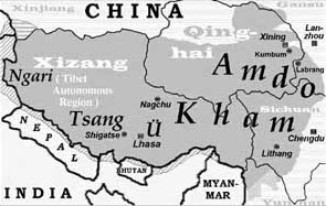
Ü-Tsang (དབུས་གཙང་། Wylie; dbus gtsang) is one of the three regions of Tibet, the others being Amdo in the north-east, and Kham in the east. The region of Ngari in the north-west is seen as being a part of Ü-Tsang. Geographically, Ü-Tsang covers the central area of Tibet, and includes the Yarlung Tsangpo River watershed, the western districts surrounding and extending past Mount Kailash, and much of the vast Changtang plateau to the north. The Himalayas define Ü-Tsang's southern border.
Ü-Tsang is the cultural heartland of the Tibetan people, originally governed by Yarlung dynasty kings from 127 BCE until the Tibetan Empire era which ended in the 9th century. During that era, the Jokhang Tibetan Buddhist temple was built in Lhasa, which is in Ü-Tsang as is the Red Fort that was later rebuilt as the Potala Palace. The Central Tibetan language is used in Ü-Tsang. By the 12th century, the Rinpungpa dynasty were the leaders of the central area. Then the Tsangpa dynasty ruled the Tsang areas between 1565 and 1642. A dispute between Tsang kings with Karma Tenkyong and the followers of the Karmapa on one side and the Khoshut Khans with Güshi Khan and the followers of the 5th Dalai Lama on the other ended when the spiritual and secular leadership of Tibet was bestowed on the Dalai Lama, who built the Potala Palace and the Norbulingka in Lhasa.
Ü-Tsang was formed by the merging of two earlier regions: Ü (Wylie: dbus) in central Tibet where the Gelug lineage of Tibetan Buddhism under the early Dalai Lamas had built monasteries, and Tsang (Wylie: gtsang) which extended from Gyantse to points west, where the Sakya lineage had its monasteries. The military victories by Güshi Khan who was a patron of the 5th Dalai Lama helped Tibet establish its Ganden Phodrang government in 1642, and combine the regions.[1][2] The retinue of the Panchen Lama was accused of using Tsang and Ü to "sow discord" in the 1950s.[3] The present Tibet Autonomous Region corresponds approximately to Ü-Tsang and the western part of Kham.
See also
[edit]References
[edit]- ^ Goldstein, Melvyn (1997). The Snow Lion and the Dragon: China, Tibet, and the Dalai Lama. Berkeley: U of California. ISBN 9780520212541.
{{cite book}}: CS1 maint: publisher location (link) - ^ Annand, Dibyesh (February 2009). "Strategic Hypocrisy: The British Imperial Scripting of Tibet's Geopolitical Identity" (PDF). The Journal of Asian Studies. 68: 227–252. doi:10.1017/s0021911809000011 – via WestminsterResearch.
- ^ Goldstein, Melvyn C. (2007). A history of modern Tibet, Volume 2: The Calm before the Storm: 1951–1955. University of California Press. pp. 217. ISBN 978-0-520-24941-7.
